Potholing in California is the process of safely exposing buried utility lines through targeted vacuum or air excavation — physically confirming the exact depth, material, and condition of underground utilities before major excavation begins. Coastline Utility Services provides professional underground utility potholing services for contractors, project managers, and municipal clients across the Central Coast and San Francisco Bay Area.
Electromagnetic locating tells you where a utility runs horizontally. Potholing confirms what is actually there — at the exact point where your excavation will occur. It is the method behind ASCE 38-02 Quality Level A, the highest standard of subsurface data quality recognized in California construction and infrastructure planning.
What Is Utility Potholing?
Utility potholing creates a small, precisely targeted excavation — called a pothole — directly above a known or suspected buried utility to physically expose the line and document its actual depth, material type, diameter, and visible condition. Unlike surface-based electromagnetic utility locating, which estimates horizontal position from above, potholing provides direct visual confirmation of subsurface conditions at a specific point.
Potholing is the method required to achieve ASCE 38-02 Quality Level A classification under Subsurface Utility Engineering (SUE) standards — the highest quality level, achievable only through physical exposure. Quality Level D relies on existing utility maps alone; Quality Level A puts a technician’s eyes and a GPS receiver directly at the utility crown.
After exposure and documentation, the pothole is backfilled to original compaction specification and the surface is restored. The entire process — excavation, documentation, and surface restoration — is completed in a single mobilization on most sites.
When Is Utility Potholing Required?
Utility potholing is the standard for damage prevention on projects where electromagnetic utility locating services alone cannot provide sufficient confidence before excavation begins. These are the scenarios where potholing is required or strongly recommended:
Utility Conflicts in Congested Corridors
On commercial construction sites and municipal infrastructure projects where multiple utility corridors intersect, potholing resolves utility conflicts before they halt a project. Congested subsurface environments — where four or five utility types run in close proximity — cannot be managed on utility maps alone. Physical exposure confirms actual clearances and prevents construction-phase redesigns.
Preconstruction Layout for Critical Installations
Before horizontal directional drilling (HDD) runs, foundation piling, utility corridor crossings, or new infrastructure installations in existing utility corridors, potholing confirms that design clearances are achievable in the actual ground. Preconstruction layout potholing prevents the most expensive construction cost: discovering a utility conflict after mobilization has already begun.
Depth Verification for Design Coordination
Utility records — including utility maps obtained through utility investigation — rarely include accurate depth information. When design plans require utilities to pass above, below, or adjacent to existing lines, potholing-produced depth data supports ground investigation accuracy that no electromagnetic method can match.
Pre Repair and Post Repair Pipeline Assessment
Before pipeline repair work begins, a Pre Repair Inspection pothole exposes the damaged or suspect section to confirm scope, material condition, and required access dimensions. After repair, a Post Repair Inspection pothole verifies restoration quality and confirms the repair meets specification — supporting pipeline assessment records and reducing return-trip risk.
Enhanced Recovery and Leak Detection Confirmation
For buried gas lines, water pipes, and fiber optic lines where condition is unknown or suspected to be compromised, potholing supports leak detection confirmation and pre-rehabilitation assessment. Enhanced Recovery Techniques applied during the potholing phase can identify active seepage, joint deterioration, and external corrosion that electronic methods cannot detect from the surface.
Subsurface Services and Utility Surveying
Municipal agencies and utility operators requiring documented utility surveying data for asset management and underground utility management programs use potholing to produce accurate as-built depth records across aging infrastructure. Potholing data supports subsurface services programs from initial utility investigation through long-term maintenance planning.

Precision Utility Line Location Services
Why Choose Coastline Utility Services for Potholing in California
Coastline Utility Services is a female-owned, family-run utility potholing and subsurface services company serving San Luis Obispo County, Santa Barbara County, and San Mateo County. Here is what separates us from lower-cost competitors and high-turnover national contractors.
Zero-Contact Excavation Policy
Every Coastline potholing crew operates under a zero-contact policy: air excavation pressure and hydro vacuum excavation water pressure are calibrated for soil extraction — never for utility contact. Our equipment operators monitor soil extraction rate and transition to manual hand digging within the utility’s protective zone on every pothole. We have never had a utility contact incident during potholing operations.
ASCE 38-02 Quality Level A Documentation
We produce complete ASCE 38-02 Quality Level A documentation on every pothole, GPS coordinates using survey benchmark accuracy, depth measurement to utility crown, material identification, photographic record, and visible condition notes. Data is delivered in formats compatible with your engineering team’s subsurface utility engineering workflows and CAD deliverables.
Complete Utility Investigation Before Every Pothole
Every pothole is preceded by complete utility locating using electromagnetic and radio frequency instruments — so our crew knows where every line runs horizontally before the vacuum nozzle goes into the ground. We do not pothole blind. Our utility detection services and potholing work as a single integrated scope, not two separate vendors.
Surface Restoration – We Leave the Site Clean
Every pothole we dig is restored to pre-excavation surface condition before we leave. Pavement patches are compacted to specification and match existing surface material. Surface restoration is included in our scope — it is not a separate line item or a task we leave for others. For potholes in public right-of-way, we handle traffic management coordination and restore to traffic-ready condition.
Rapid Response for Schedule-Critical Projects
Utility conflicts and preconstruction potholing windows are frequently on the critical path of a construction schedule. Coastline Utility Services offers rapid response scheduling — project requests confirmed within 24 hours, with site visits within 1–3 business days. For time-critical utility investigation needs, same-day or next-day scheduling is available. Call (805) 234-4620 directly for urgent requests.
Alternative Solutions When Conditions Change
No two sites are the same. When soil conditions, access constraints, or utility sensitivity make the planned method impractical, we adapt with alternative solutions — switching from hydro to air excavation near sensitive fiber optic lines, adjusting extraction rates in sandy soils, or coordinating traffic management for unexpected right-of-way access issues. Our team solves problems on site rather than sending them back to the office.
What Our Clients Say About Our Potholing Services
Coastline Utility Services holds a 5-star rating across Google My Business, Top Rated Local, and Facebook.
"We had a congested utility corridor on a commercial site in San Luis Obispo where our locates showed four overlapping utilities within 18 inches of each other. Coastline potholed all four on a single day mobilization, delivered GPS depth data, and we had ASCE QL-A documentation in our hands within 48 hours. That data saved us from a conflict on our HDD run that would have cost weeks."
"Fast scheduling, clean work, and they left the site exactly as they found it. I needed three potholes along a proposed fence line before we broke ground on a commercial property. Coastline was on site in two days, marked the depths on the report, and I had everything I needed for my engineer before the end of the week."
Schedule Your Potholing Service Today
Don’t start excavation with a question mark in your subsurface. Whether you are a project manager resolving utility conflicts on a commercial development, a contractor confirming depths for an HDD run, or a property owner planning a major digging project, Coastline Utility Services provides the ASCE QL-A damage prevention documentation your project requires before a single cubic foot of soil moves. Contact us to schedule your potholing service today!
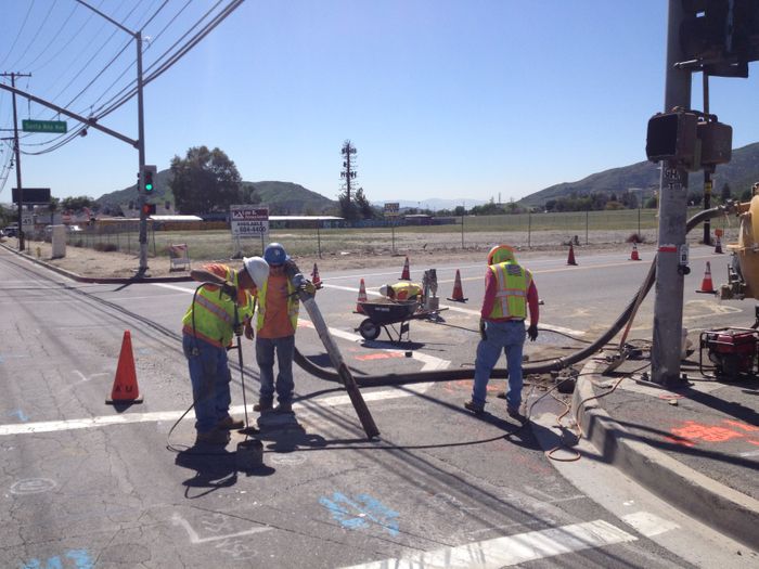
The value of Potholing
At Coastline Utility Services we believe that potholing provides great accuracy in avoiding damage to underground utility lines during construction that involves earthmoving or excavation. Potholing minimizes this risk by giving the exact location of utility lines such as water, sewer, electricity or gas. This practice can greatly reduce the risk of disruption to existing utilities and the overall project.
Want to learn more?
At Coastline Utility Services we are here to help you find the right solution and modality for all your utility locating needs.
Frequently Asked Questions About Potholing in California
What is the difference between utility potholing and utility locating?
Utility locating uses electromagnetic induction, ground penetrating radar, and acoustic methods to detect and map buried utility lines from above ground — establishing horizontal position and estimated depth. Utility potholing physically excavates a small targeted hole to expose the utility at a specific point, confirming exact depth, material, diameter, and visible condition. Potholing provides ASCE 38-02 Quality Level A data; surface-based locating provides Quality Level B or C. Both are used together — locating first to establish the target zone, potholing to confirm.
What is ASCE 38-02 Quality Level A and why does it matter?
ASCE 38-02 is the American Society of Civil Engineers standard for the collection and depiction of existing subsurface utility data. Quality Level A is the highest classification and requires physical exposure of the utility — achieved through potholing. Quality Level D relies on existing utility maps only; Quality Level A provides the measured, confirmed data needed for design coordination, HDD planning, and cost estimation on complex infrastructure projects. Specifying QL-A data in a project’s subsurface utility engineering scope means potholing is required, not optional.
What is the difference between air excavation and hydro excavation for potholing?
Air excavation (also called air vacuum excavation or abrasive excavation) uses compressed air to break up soil and a vacuum to extract it — no water involved. It is preferred near fiber optic lines, electrical cables, and utilities sensitive to water contact. Hydro excavation (hydrovac) uses high-pressure water to break soil and a vacuum to extract the slurry — faster in dense or rocky soils but produces wet spoil requiring licensed disposal. Both methods are ASCE QL-A capable and non-destructive when operated correctly.
How deep can you pothole?
Coastline Utility Services performs standard utility potholes to depths of 6–8 feet. Deeper potholes — required for large-diameter transmission mains, deep sewer interceptors, or utilities below the water table — are scoped individually based on soil conditions, shoring requirements, and OSHA confined space protocols. Call (805) 234-4620 with your depth specification for an accurate assessment.
Do you restore the surface after potholing?
Yes. Surface restoration is included in every Coastline potholing scope. We backfill, compact, and restore the surface to match pre-excavation material and grade. For paved surfaces, we apply a compacted aggregate base and asphalt or concrete patch to the applicable local specification. We coordinate traffic management for potholes in public right-of-way and restore to traffic-ready condition before demobilizing.
How long does a utility potholing service take?
A standard residential or light commercial pothole — single hole, ≤6 ft depth, accessible soil — typically takes 2–4 hours including documentation and surface restoration. A multi-hole commercial program on a congested corridor may take a full day or span multiple mobilizations depending on site conditions, access, and traffic management requirements. Most potholing requests are scheduled within 1–3 business days of the locate request.
Can potholing be used to confirm a gas line leak?
Yes. Potholing is used in leak detection programs to expose a gas line at a suspect location so that direct measurement with a combustible gas detector can confirm or rule out an active leak at the pipe surface. Potholing for Pre Repair Inspection also establishes the excavation scope and ground conditions required for repair planning. For active gas lines suspected of leaking, potholing must be carried out in coordination with the gas utility operator — Coastline coordinates this notification process as part of the service scope.
What projects most commonly require utility potholing in California?
The most common potholing projects include: commercial site development with congested utility corridors, horizontal directional drilling (HDD) planning, municipal infrastructure installation, pipeline assessment programs for aging water and sewer infrastructure, preconstruction layout for foundation work near existing utilities, fiber optic lines installation and relocation planning, utility surveying for asset management programs, and residential projects where depth verification is needed before major excavation near known utility lines.
At Coastline Utility, we take pride in our ability to deliver exceptional service that meets the unique needs of our clients. Our team of experts is dedicated to providing reliable and efficient services that exceed your expectations. So, if you need private utility line location services on the Central Coast or Bay Area look no further than Coastline Utility. Contact us today!
