Utility locating in California is the professional practice of detecting, mapping, and marking every buried utility line before excavation begins. Coastline Utility Services locates gas pipelines, water pipes, electrical cables, communication cables, sewer mains, storm drains, and post-tension cables for residential and commercial projects across the Central Coast and San Francisco Bay Area.
California’s dig laws require utility notification before any ground disturbance. But 811 (Dig Alert) notification marks only publicly owned utility mains — it does not cover private service laterals, irrigation lines, or utilities installed without permits. Professional private utility locating fills that gap. Coastline Utility Services delivers accurate subsurface investigation, GPS-mapped locating maps, and written documentation from locate request through final site marking.
What Is Underground Utility Locating?
Underground utility locating is the process of detecting, identifying, and marking buried utility lines and subsurface installations before any digging begins. Using electromagnetic induction, ground penetrating radar systems, magnetic locators, and acoustic leak detection equipment, utility locators establish the horizontal position and depth of buried infrastructure — including both metallic and non-metallic lines — across a project site.
Utility maps on file with municipalities and utility operators are frequently inaccurate, outdated, or incomplete. Private lines — service laterals, private electrical runs, irrigation systems, and utilities installed without permits — often do not appear on public records at all. These are the lines that cause the most damage, because they are the lines no one is looking for.
Coastline Utility Services provides complete underground private utility locating alongside 811 ticket management coordination, delivering a full subsurface picture before excavation begins. Every locate confirms actual line positions — not where records say lines should be.
Our Utility Locating Process: Step by Step
Coastline Utility Services follows a documented subsurface investigation methodology that aligns with Common Ground Alliance best practices for locating and marking. Here is what happens from the moment you submit a locate request through final site deliverables.
Step 1: Locate Request and Project Briefing (Same Day)
You call (805) 234-4620 or submit a request at coastlineutility.com. We collect the project address, scope of excavation, access conditions, property type, and preferred scheduling window. Most requests are confirmed within 24 hours and scheduled within 1–3 business days. Emergency and rapid response scheduling is available for time-sensitive projects where excavation cannot wait.
Step 2: 811 Ticket Management Coordination (If Applicable)
For projects involving public utility lines, we coordinate with California’s 811 excavation request system. We manage 811 ticket status, track operator response, and follow up on overdue marks so your team does not have to chase multiple utility operators before breaking ground. This process runs in parallel with our private locate — not sequentially after it.
Step 3: Subsurface Investigation
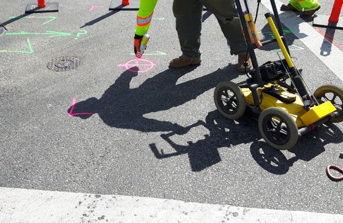
Our technicians arrive on site with a complete array of utility locate equipment: electromagnetic pipe and cable locators, ground penetrating radar systems, magnetic locators, and — where site conditions require it — the LD-12 Acoustic Leak Detector for pressurized water line leak detection. We use both active and passive electromagnetic induction methods to trace metallic utility lines, and GPR to detect non-metallic lines including plastic water pipes, concrete-encased utilities, and post-tension cables within slabs.
Step 4: GPS Mapping with Real-Time Kinematic Positioning
All confirmed utility locations are GPS-tagged using Real-Time Kinematic (RTK) positioning with our Trimble Robotic Total Station — the same survey-grade positioning technology used by civil engineers. Data is compiled into professional locating maps showing confirmed utility positions and depths. For commercial projects requiring CAD & BIM integration, we deliver data in compatible file formats for project managers and engineers.
Step 5: Site Marking
Confirmed utility locations are marked on site using color-coded flags and paint that follow APWA utility marking standards: red for electrical, yellow for gas, blue for water, green for sewer and drain, orange for communications. Every mark includes depth indicators where surface area allows. Marking follows locating and marking best practices established by the Common Ground Alliance for safe digging practices.
Step 6: Written Locate Report and Deliverables
You receive a professionally formatted locate report with GPS-mapped utility positions, confirmed depths, and a permanent project record. This documentation protects contractors from regulatory liability, satisfies compliance requirements, and gives property owners a reference for future digging. We do not provide a hand-drawn sketch — you receive a real deliverable.
Underground Utility Types We Locate in California
Coastline Utility Services locates every type of buried utility line for residential and commercial clients. Each utility type requires specific detection techniques and specialized equipment. Our technicians are trained across all methods — we do not rely on a single technology.
Gas Line Locating
Gas line locating uses electromagnetic locators to detect and trace pressurized gas pipelines. Gas line strikes are the most dangerous utility accidents — triggering emergency evacuations, fires, and regulatory investigations. We confirm gas pipeline location and depth before any excavation in the vicinity of a gas service or main.
Water Pipe Locating
Water pipe locating covers both metallic water mains and non-metallic (plastic PVC and HDPE) service lines. Electromagnetic methods detect metallic copper and steel water lines; GPR detects plastic water pipes that electromagnetic induction cannot trace. We locate water lines from public mains down to private service laterals, including irrigation systems not connected to the public utility grid.
Electrical Cable Locating
Electrical cable locating uses electromagnetic induction to trace energized underground cables and trace methods for de-energized lines. We locate high-voltage transmission lines, underground service cables, and private electrical runs — including lines installed by previous property owners that may not appear in any utility records.
Communication Cable Locating
Communication cable locating detects buried fiber optic, coaxial, and copper telecommunication cables using locators calibrated for low-signal lines. Cutting a buried telecom cable can interrupt service for thousands of customers and trigger significant emergency response costs from carriers.
Sewer Main Locating
Sewer main locating uses electromagnetic pipe locators and — for complex or aged systems — NASSCO-certified video pipe inspection using high-resolution CCTV cameras. NASSCO-certified inspection produces PACP-coded defect reports for municipal acceptance, pre-sale due diligence, and infrastructure rehabilitation planning.
Storm Drain Locating
Storm drain locating identifies stormwater infrastructure — catch basins, culverts, and drain tile runs — that may not appear on standard utility maps. Storm drain location is particularly critical for fence installation, landscape drainage grading, and new construction near existing stormwater systems.
Concrete Scanning – Post-Tension Cable and Rebar Detection
Before cutting into any concrete slab, our Concrete Scanner detects post-tension cables, rebar, conduit, and voids within the slab using ground penetrating radar. Cutting a post-tension cable causes immediate structural damage and serious worker injury risk. GPR concrete scanning is required for any core drilling, saw cutting, or anchor installation on post-tensioned structures.

Precision Utility Line Location Services
Our team of experts utilizes state-of-the-art equipment and advanced techniques to accurately locate all underground utility lines, minimizing the risk of damage or interruption of service. We provide high-quality, cost-effective solutions that ensure our clients’ satisfaction every step of the way.
Private Utility Locating Vs. 811 in California – What’s the Difference?
Many contractors and homeowners assume that calling 811 before digging covers all underground utilities. It does not. Understanding the difference between public 811 excavation requests and professional private utility locating is essential for damage prevention and regulatory compliance.
| Factor | 811 (Dig Alert California) | Private Utility Locating — Coastline |
|---|---|---|
| What it covers | Publicly owned utility mains only | Private lines, service laterals, non-permitted utilities, and everything 811 does not mark |
| Who marks lines | Individual utility operators (arrival times vary) | Coastline Utility Services — single crew, confirmed scheduling |
| Accuracy | Best-effort; utility maps may be outdated or inaccurate | RTK GPS positioning with Trimble Robotic Total Station — centimeter-level accuracy |
| Non-metallic lines (plastic pipe, HDPE) | Typically not located — EM methods can’t detect | GPR detects metallic and non-metallic lines including plastic water pipes |
| Documentation | Color-coded stakes from multiple operators, no report | Comprehensive locating map with GPS coordinates, confirmed depths, written report |
| Timeframe | 2–3 business days minimum; completion not guaranteed | Typically 1–3 business days; emergency same-day scheduling available |
| Concrete/slab utilities | Not covered | GPR concrete scanning for post-tension cables, rebar, and conduit |
| Compliance documentation | None provided | Full written locate report for contractor liability protection |
Why Choose Coastline Utility Services for Utility Locating in California
Coastline Utility Services is a contract locating company operating across San Luis Obispo County, San Mateo County, and Santa Barbara County. Here is what separates us from national utility operators with high turnover and lower-cost competitors using outdated equipment.
Survey-Grade GPS Accuracy
Most locating companies mark lines using handheld GPS with 3–5 meter positional accuracy. Coastline Utility Services uses a Trimble Robotic Total Station with Real-Time Kinematic Positioning — centimeter-level GPS accuracy on every locate. The difference between a marked line and a struck line is often measured in inches. Our positioning technology closes that gap.
NASSCO-Certified Video Pipe Inspection
For sewer locating and condition assessment, our NASSCO-Certified Video Pipe Inspection delivers PACP-coded defect reports using high-resolution sewer camera systems. This is the industry standard for municipal sewer acceptance, pre-sale due diligence, and infrastructure rehabilitation planning.
Full Detection Technology Suite
Our technicians carry electromagnetic locators, ground penetrating radar systems, magnetic locators, and the LD-12 Acoustic Leak Detector for pressurized water line leak detection. When one detection method cannot find a line, another one will. We do not send a single-method crew to a multi-utility site.
CAD & BIM-Compatible Deliverables
For commercial projects where engineers and project managers need subsurface data integrated into design models, we deliver locate data compatible with CAD & BIM workflows. Select complex sites also qualify for LiDAR scanners and 3D Laser Scanning to produce full subsurface-to-surface models for infrastructure solutions requiring engineering-grade documentation.
811 Ticket Management Support
Managing 811 excavation requests and tracking operator response for multiple active projects is time-consuming for contractors and project managers. Coastline Utility Services handles 811 ticket management coordination — tracking dig alert status, following up with utility operators, and confirming operator marks before excavation begins.
Rapid Response, Direct Communication
You deal with our team directly — not a national call center. Rapid response scheduling is available for time-sensitive excavation projects. As a family-owned business, we provide direct access to decision-makers who understand project timelines and can adapt to urgent site conditions without bureaucratic delay.
What Contractors and Homeowners Say About Our Utility Locating Services
Coastline Utility Services holds a 5-star rating across Google My Business, Top Rated Local, and Facebook.
“Coastline found three unmarked private lines our 811 marks did not pick up — including a gas lateral running diagonally across the excavation zone. That find prevented what would have been a serious incident. Their GPS mapping report was something I could file for compliance. That kind of documentation is what separates a real locating company from a guy with a wand.”
“I was installing a fence line across the back of my property. Coastline came out, located everything including a private irrigation main I had no idea was there, and marked the whole run clearly. The whole process — from my locate request to marks on the ground — was three days. That is exactly what you need.”
Request a Utility Locate Today
Don’t break ground without knowing what is below. Whether you are a contractor managing a commercial excavation, a project manager coordinating a municipal infrastructure project, or a homeowner planning a pool or fence installation, Coastline Utility Services provides the accurate utility mapping and damage prevention documentation your project requires.

Know What’s Below: Importance of Utility Line Location
At Coastline Utility, we understand the importance of utility line locating when it comes to private property ownership and development. As experts in utility line location on the Central Coast and Bay Area we take great pride in offering our clients top-notch services that are grounded in our experience and knowledge.
- Accurate and Reliable Results
- Cost-Effective
- Avoid Risks
- Fast and Efficient
- Protect Your Property
Protect Your Property
We know there are many reasons why a property owner may need utility line locating services. Perhaps you want to install a new swimming pool, add a patio, or even plant a garden. Using our state-of-the-art equipment, we can identify the exact location of your utility lines without causing any damage to your property.
Frequently Asked Questions About Utility Locating in California
What types of underground utilities does Coastline Utility Services locate?
Coastline locates gas pipelines, water pipes (metallic and non-metallic), electrical cables, communication cables, sewer mains, storm drains, irrigation lines, and post-tension cables within concrete slabs. Both public utility mains and private subsurface installations are within scope. We handle every utility type found on residential properties and commercial construction sites across California’s Central Coast and Bay Area.
What is the difference between active and passive utility locating?
Active utility locating applies a signal directly to a known utility — via a physical connection or inductive clamp — and traces that specific line’s signal above ground. Passive utility locating detects electromagnetic signals already present on buried utilities — power line emissions and broadcast radio frequencies. A complete locate uses both methods: active for confirmed lines, passive to detect lines not previously identified. Coastline Utility Services performs both in every standard locate.
Can ground penetrating radar detect plastic (non-metallic) pipes?
Yes. Ground penetrating radar detects both metallic and non-metallic lines by mapping changes in subsurface material density — not by tracing electromagnetic signals. GPR locates plastic PVC and HDPE water pipes, concrete-encased conduit, and non-conductive utility lines that electromagnetic induction methods cannot detect. Non-metallic line detection is one of the primary reasons GPR is standard on every Coastline locate.
What is concrete scanning and when is it required?
Concrete scanning uses ground penetrating radar to detect post-tension cables, rebar, conduit, and voids within concrete slabs before core drilling, saw cutting, anchor installation, or any slab penetration. Post-tension cables carry extreme tension — cutting one causes immediate structural failure and serious worker injury risk. Concrete scanning is required before any penetration of a post-tensioned slab, and is strongly recommended before any structural core drilling regardless of slab type.
What is NASSCO-certified video pipe inspection?
NASSCO (National Association of Sewer Service Companies) certification establishes the standard for sewer condition assessment using CCTV cameras. NASSCO-certified inspectors follow the Pipeline Assessment and Certification Program (PACP) to systematically document and code sewer defects during a video pipe inspection. PACP-coded defect reports are required by many California municipalities for sewer system acceptance, pre-purchase due diligence, and rehabilitation planning approval.
How does Coastline Utility Services handle 811 ticket management?
For clients managing multiple concurrent excavation projects, we coordinate 811 excavation requests directly — submitting tickets, tracking operator response timelines, following up on overdue marks, and confirming all public utility marks are in place before excavation begins. This removes the coordination burden from project managers and ensures 811 compliance runs in parallel with our private locate, not as a separate waiting period that delays your schedule.
What is Subsurface Utility Engineering (SUE) and do you offer it?
Subsurface Utility Engineering (SUE) is a formal engineering process for managing risk related to existing underground infrastructure on construction and infrastructure projects. SUE involves systematic data collection, quality levels from QL-D (record research) through QL-A (physical exposure via potholing), and deliverable integration into project design through CAD & BIM. Coastline Utility Services applies SUE methodology on commercial projects requiring engineering-grade subsurface documentation.
What projects most commonly require private utility locating in California?
The most common projects requiring private utility locating include: pool and spa installation, patio and hardscape construction, fence installation, landscape and irrigation work, drain tile installation, general contracting and site development, commercial excavation and utility infrastructure work, and any digging on properties where utility records are incomplete or suspected to be inaccurate. Any project involving ground disturbance on private property should include a private utility locate in addition to 811 notification.
How do I schedule a utility locate with Coastline Utility Services?
Call (805) 234-4620 or submit a locate request at coastlineutility.com. We collect project address, excavation scope, and access details. Confirmation is typically within 24 hours, with site visits scheduled within 1–3 business days. Emergency and rapid response scheduling is available — call directly for time-sensitive requests.
At Coastline Utility, we take pride in our ability to deliver exceptional service that meets the unique needs of our clients. Our team of experts is dedicated to providing reliable and efficient services that exceed your expectations. So, if you need private utility line location services on the Central Coast or Bay Area look no further than Coastline Utility. Contact us today!
