
GPR vs. Electromagnetic Utility Locating
Commercial construction projects demand accurate subsurface information before excavation begins. Utility strikes cost contractors thousands in delays, repairs, and safety violations. The global utility locator market reached $1.03 billion in 2026 and is projected to grow at 6.02% annually through 2031.
Two technologies dominate the field: Ground Penetrating Radar and electromagnetic locating. Each method offers distinct advantages depending on site conditions, utility types, and project requirements. Understanding when to deploy each technology prevents costly mistakes and ensures regulatory compliance.
Key Takeaways
- GPR detects both metallic and non-metallic utilities, while EM locates only conductive lines unless tracer wire is installed
- Every dollar spent on utility mapping produces $11.39 in savings through reduced relocation costs and project delays
- EM equipment costs $1,500 to $8,000, while GPR systems range from $10,000 to over $70,000 for premium models
- The oil and gas sector accounts for 28.60% of the utility locating market share, with telecommunications growing at 7.46% annually
- Hybrid approaches combining GPR and EM are becoming standard practice for complete subsurface mapping in congested urban sites
How Each Technology Works
Ground Penetrating Radar (GPR)
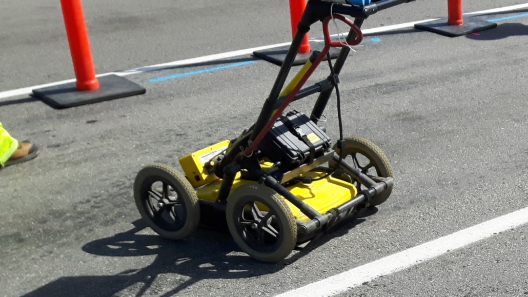
Ground Penetrating Radar uses high-frequency radio waves to detect buried objects by analyzing signals reflected from changes in subsurface material properties. The system transmits pulses into the ground and records echoes that bounce back from underground features. The resulting data creates a cross-sectional image showing utility locations, depths, and soil layers beneath the surface.
Electromagnetic (EM) Locating
Electromagnetic locating induces a specific frequency onto a conductive utility line and traces the resulting electromagnetic field using a receiver. The transmitter applies an electrical signal to the target line, creating a magnetic field that radiates outward. An operator walks the site with a receiver, identifying the signal strength and position to map the utility’s horizontal path.
What Each Can Detect
GPR detects both metallic and non-metallic utilities, including PVC pipes, concrete structures, and fiberglass conduits. The technology responds to changes in subsurface density regardless of material conductivity. Electromagnetic locating detects metallic utilities only, unless a tracer wire is installed alongside non-conductive infrastructure. Copper, steel, and aluminum lines carry signals effectively, while plastic and concrete remain invisible to EM receivers.
GPR vs. EM: Head-to-Head Comparison
| Dimension | Ground Penetrating Radar (GPR) | Electromagnetic (EM) Locating |
| Utilities detected | Metallic and non-metallic | Metallic only (unless tracer wire is installed) |
| Depth estimation | Superior depth estimation | Less precise on depth |
| Speed | Generally more time-consuming | Faster |
| Cost | Higher capital investment | More affordable |
| Soil and environment | Effectiveness is highly dependent on soil; wet clay severely limits penetration | The main environmental challenge is signal bleed-off in congested urban areas |
| Urban congestion | Comprehensive imaging across congested sites | Signal complications and bleed-off to adjacent metallic structures |
| Market share (2025) | — | Commanded 46.40% of market share |
What the Comparison Means
GPR wins on detection range and depth: it sees non-metallic lines and estimates depth more accurately than electromagnetic methods. The technology provides comprehensive subsurface imaging that reveals utilities missed by EM scans. Electromagnetic survey benefits include faster operation and lower costs for known metallic lines. Equipment investments start below $2,000, making EM accessible to small contractors with limited budgets.
Neither method is universally superior; the right choice depends on the site conditions and project scope. Urban projects with mixed utility materials favor GPR, while rural metallic-only sites suit EM locating. Most commercial construction projects now combine both technologies for complete coverage.
When to Use Each Technology
Site Conditions and Technology Selection
Use GPR where non-metallic lines—PVC, concrete, or fiberglass—or unknown utilities are present, or where depth must be confirmed. Accurate depth estimation prevents excavator strikes during trenching and prevents damage to underground utility infrastructure. Use EM where target lines are known and metallic, and speed or budget is the priority. Tracing existing power, gas, and communication lines works efficiently with electromagnetic receivers when the material composition is documented.
Urban vs. Rural Preferences
Congested urban sites raise EM signal bleed-off risk, favoring GPR or a combined approach for accurate mapping. Adjacent metallic structures create interference that complicates signal interpretation, requiring experienced operators to distinguish target utilities from background noise. Open or known-metallic sites suit faster, lower-cost EM locating without the environmental challenges that reduce radar penetration. Rural pipeline corridors and transmission line projects typically deploy EM as the primary method.
Why a Hybrid Approach Is Becoming Standard
A hybrid approach combines EM rapid metallic detection with GPR comprehensive imaging for complete utility mapping across diverse site conditions. The utility locating methods comparison shows complementary strengths: EM confirms conductive line positions, while GPR reveals non-metallic infrastructure and subsurface voids. Contractors reduce liability by verifying data through dual-technology verification before excavation begins.
Why the Comparison Matters in Commercial Construction
Common Applications by Sector
The oil and gas sector accounts for 28.60% of the market in 2025, driven by pipeline expansion and maintenance projects. Petroleum infrastructure relies heavily on electromagnetic methods to trace metallic pipelines across long distances. The telecommunications sector is growing at 7.46% annually as fiber-optic network deployment accelerates nationwide. Fiber installation requires GPR to avoid damaging existing non-metallic conduits that EM systems cannot detect.
Accuracy, Speed, and Safety Stakes
Seventy-eight percent of respondents identified the lack of accurate utility locating as the weakest element in the 811 damage prevention process. Inaccurate subsurface data leads directly to utility strikes, project delays, and safety incidents that halt construction. Fifty-six percent of contractors cited response time issues as a major weakness in current locating services. Slow turnarounds force project managers to choose between waiting for accurate data or proceeding with incomplete information.
Cost, ROI, and the Business Case
Equipment Costs Compared
GPR equipment requires substantial capital investment: basic units start around $10,000, while premium 3D systems exceed $70,000 for advanced imaging. Complete systems average $65,000, including accessories, training, and software for professional utility line locator operations. EM equipment costs significantly less: professional mid-range models cost $1,500 to $5,000 for reliable metallic detection. Premium multi-frequency models reach $8,000 but remain far below GPR investment thresholds.
ROI From Subsurface Utility Engineering (SUE)
Every $1.00 spent on utility mapping produced $11.39 in savings through reduced relocation costs and design changes. Projects using comprehensive subsurface data experienced 40.33% reduction in relocation costs compared to excavation without mapping. Construction and design costs dropped 29.46%, while redesign costs fell 9.59% when accurate utility data informed planning. Project delays decreased 9.08% when contractors identified conflicts before mobilizing equipment.
Case Studies in Cost Avoidance
Virginia DOT invested $93,553 in test holes and utility locating, identified 75 potential conflicts, and eliminated 61 before construction. The proactive approach avoided $731,425 in utility adjustments for net savings of $637,872 on a single project. Maryland State Highway Administration invested $5,000 in SUE, avoided major utility conflicts, and realized $300,000 in savings. Relocation time dropped by four to six months, accelerating project delivery and reducing overhead costs.
Who Adopts Each Technology
Workforce and Demographic Trends
The median age of the construction workforce is 42 years, indicating an experienced labor pool familiar with traditional methods. Millennials and Generation X comprise 71% of the workforce, representing tech-savvy professionals receptive to advanced detection systems. Younger workers adopt GPR technology faster than older cohorts, driving gradual industry-wide shifts from electromagnetic-only operations to hybrid approaches.
Firm Size and Budget Constraints
Ninety-nine point nine four percent of construction companies are classified as small businesses, which pushes many firms toward EM’s lower equipment cost. Limited capital budgets prevent small contractors from purchasing GPR systems outright, forcing them to rent equipment or subcontract locating services. Large engineering firms invest in both technologies to serve diverse project types, while smaller operations specialize in one method or partner with professional utility marking companies for comprehensive coverage.
Emerging Technologies Beyond GPR and EM
AI-Based Subsurface Prediction
4M Analytics uses machine learning to analyze satellite imagery, aerial photos, historical maps, and public utility records before fieldwork begins. The system identifies surface clues—fire hydrants, manholes, and utility poles—to infer subsurface infrastructure location with increasing accuracy. AI analyzes patterns invisible to human observers, predicting utility corridors that field teams verify using GPR and EM.
Detection Integrated With Excavation
RodRadar offers real-time utility detection integrated into excavator buckets, automatically halting digging operations when conductors are detected. The system provides immediate feedback to operators, preventing strikes before damage occurs rather than relying on pre-excavation surveys alone. Integration reduces human error by removing the gap between locating data and excavation execution.
The Verdict: GPR Vs. EM for Commercial Construction
GPR and EM are not rivals so much as complementary tools: GPR for non-metallic lines and depth, EM for fast, low-cost metallic detection. Choosing the right utility locating technique depends on project scope, known infrastructure, and site complexity. Site conditions, utility materials, and congestion decide which method leads on a given job, with hybrid approaches becoming standard practice.
The hybrid approach is becoming the standard because it captures the strengths of both technologies while compensating for individual limitations. Commercial projects demand complete subsurface data, which no single technology provides across all conditions. GPR utility detection advantages include comprehensive imaging of mixed-material infrastructure, while EM delivers rapid metallic tracing at accessible price points.
Coastline Utility uses both EM and GPR to deliver complete utility locating for commercial construction projects and residential applications across the Central Coast and SF Bay Area. The ground penetrating radar vs. electromagnetic debate misses the point: effective subsurface mapping requires both technologies deployed strategically based on site-specific conditions.
Get Both Technologies on Your Next Job Site
The wrong locating method leaves utilities undetected and your crew exposed. Coastline Utility runs electromagnetic and GPR side by side, so metallic lines, PVC, concrete, and unknown infrastructure all get mapped before your excavator touches the ground. You get accurate depth, complete coverage, and the documentation you need to stay compliant on Central Coast and SF Bay Area projects. Request a free quote or schedule your locating service.
