
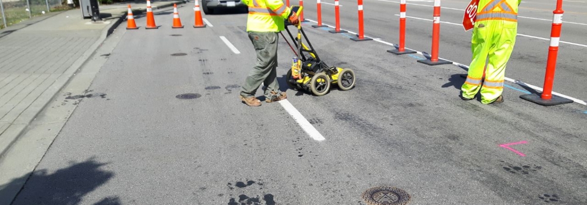
How Sacramento Contractors Reduce Liability with Private Utility Locating
Sacramento contractors face increasing pressure to prevent utility strikes that result in project delays, regulatory penalties, and financial losses. Private utility locating services provide accurate subsurface infrastructure mapping beyond what public 811 services cover, protecting contractors from liability exposure. The Sacramento market shows strong adoption of advanced detection technologies, with municipal contractors reaching 92% utilization rates and excavation specialists at 85% adoption.
Professional private utility locating addresses the responsibility gap where 60% of subsurface infrastructure exists beyond the public meter. California regulations require contractors to identify these private utilities before excavation, shifting liability to project managers who fail to conduct proper assessments. Sacramento’s complex urban infrastructure and strict compliance requirements make comprehensive utility detection essential for contractor liability reduction.
Key Takeaways
- Private utility locating identifies subsurface infrastructure beyond the public meter, covering 60% of utilities not marked by 811 services
- Advanced technologies like Ground Penetrating Radar detect both metallic and non-metallic utilities with excellent accuracy
- California regulatory fines for utility strikes can reach $100,000 for state violations and $2,000,000 for federal pipeline damages
- Municipal contractors demonstrate 92% adoption rates, while commercial renovators show 68% adoption of professional locating services
- Sacramento contractors prevented $45,000 in potential damages through proactive private utility locating on downtown renovation projects
What Is Private Utility Locating and Why Is It Important for Contractors?
Private utility locating identifies subsurface infrastructure beyond the public meter or service connection point. These utilities include private water lines to secondary buildings, electrical conduits serving outbuildings, irrigation systems, and telecommunications cables installed by property owners. Sacramento contractors must locate these private systems because public 811 services only mark utilities up to the meter.
The importance stems from the financial and regulatory consequences of striking unmarked utilities. Direct repair costs average $4,000 per strike, but indirect costs, including project delays and legal expenses, multiply this figure significantly. California law holds contractors liable for damages when they fail to identify private utilities before excavation.
What Utilities Are Covered Beyond the Public Meter?
Private utility systems include water lines extending from the meter to multiple buildings on commercial properties. Electrical conduits serving detached garages, workshops, and accessory structures require identification before ground disturbance. Irrigation systems with PVC piping throughout landscaped areas create hidden strike risks that electromagnetic methods cannot detect.
Telecommunications infrastructure installed by property owners for security systems and internet connectivity also falls under private utility categories. Private gas lines serving outdoor kitchens, pool heaters, and secondary structures present serious safety hazards when struck. These systems require specialized detection because property owners often lack accurate installation records.
How Does Private Locating Differ from 811 Public Services?
California’s 811 service marks public utilities from the main line to the meter or property connection point. Private utilities beyond this demarcation point constitute 60% of subsurface infrastructure but receive no coverage from free public services. This responsibility gap leaves contractors vulnerable to striking unmarked systems if they rely solely on 811 notifications.
Public services typically respond within two business days and use basic electromagnetic detection for metallic utilities. Understanding the regulations surrounding utility line marking in California reveals that contractors must independently verify private utility locations using professional locating services. Private locators employ multiple detection technologies, including Ground Penetrating Radar, to identify both metallic and non-metallic infrastructure.
What Are the Typical Service Categories and Pricing Tiers?
Private utility locating holds 35% market share in Sacramento’s utility detection industry, representing the largest service category. Commercial excavation support accounts for 28% of market activity, focusing on comprehensive site scanning and engineering standards integration. Liability risk mitigation services capture 22% market share by providing documentation and compliance verification.
Concrete scanning represents 10% of market activity for projects requiring structural analysis before drilling or cutting. Other specialized services, including leak detection and acoustic methods, hold the remaining 5%. Pricing varies from $150 for basic residential electromagnetic scans to $25,000 for comprehensive commercial campus mapping.
How Do Private Utility Locating Technologies Compare in Accuracy and Application?
Technology selection determines detection accuracy and project suitability for utility mapping services. Electromagnetic locating provides fast, cost-effective metallic utility detection but cannot identify non-metallic infrastructure. Ground Penetrating Radar offers comprehensive detection of all utility types with excellent depth capability despite higher costs.
Each technology presents distinct advantages and limitations that contractors must evaluate based on project requirements. Site conditions, including soil composition and utility material types, influence which detection method delivers optimal results. Sacramento contractors increasingly adopt multiple technologies to ensure complete subsurface infrastructure identification.
What Are the Strengths and Limitations of Electromagnetic (EM) Locating?
Electromagnetic locating excels at detecting metallic utilities with very fast scanning speeds and low costs. The technology applies electrical signals to conductive utilities and traces the resulting electromagnetic field to determine location and depth. This method provides excellent accuracy for copper water lines, steel gas pipes, and metallic electrical conduits.
Electromagnetic systems cannot detect PVC pipes, concrete structures, or fiber-optic cables that lack conductive properties. Clay-rich soils in some Sacramento areas reduce signal strength and detection accuracy for deeper utilities. These limitations require contractors to supplement electromagnetic scans with additional technologies when non-metallic utilities are suspected.
How Does Ground Penetrating Radar (GPR) Enhance Utility Detection?
Ground Penetrating Radar transmits radio waves into the ground and analyzes reflected signals to identify subsurface objects. This technology detects both metallic and non-metallic utilities with excellent depth capability reaching 15 feet or more. GPR provides detailed subsurface imaging that reveals utility sizes, depths, and relationships between multiple infrastructure elements.
High-clay soil conditions common in parts of California reduce radar wave penetration and signal clarity. GPR scanning requires moderate time investment compared to electromagnetic methods but delivers comprehensive results essential for complex projects. Sacramento contractors working on commercial excavation projects rely on GPR for accurate utility mapping before major ground disturbances.
When Are Advanced Methods Like Vacuum Excavation Used?
Vacuum excavation provides Quality Level A data through direct visual confirmation of utility locations and characteristics. This non-destructive method uses pressurized air or water to break up soil while simultaneously vacuuming the debris. Contractors employ vacuum excavation when projects require absolute certainty about utility positions before heavy equipment operations.
The technology offers excellent accuracy for both metallic and non-metallic utilities with unlimited effective depth. Vacuum excavation demands very high costs and slow operational speeds that limit its application to critical verification points. What are the risks of not prioritizing utility marking for construction sites? Justifying these advanced methods when potential strike consequences outweigh investigation costs.
What Regulatory Requirements Affect Utility Locating in Sacramento?
California enforces strict excavation regulations that significantly impact contractor operations and liability exposure. State law mandates contact with USA North 811 at least two business days before any digging activity. These regulations protect public infrastructure but leave contractors responsible for identifying private utilities beyond the meter.
Compliance failures result in severe financial penalties and potential criminal charges when utility strikes cause injuries or service disruptions. Sacramento contractors must navigate both state requirements and federal pipeline safety regulations that impose additional liability. Understanding these regulatory frameworks becomes essential for contractor liability reduction strategies.
How Does California’s 811 System Define Contractor Responsibilities?
California Government Code requires excavators to contact USA North 811 before starting any project involving ground disturbance. The notification must occur at least two full working days before excavation, excluding weekends and holidays. This requirement applies to all digging activities regardless of project size or depth.
Contractors must accurately describe the excavation area and mark proposed dig site boundaries with white paint. Underground utilities in California remain marked for 28 days from the initial 811 request, requiring ticket renewals for longer projects. The 811 system provides free marking for public utilities but explicitly excludes private infrastructure from coverage.
What Are the Legal Risks and Penalties for Utility Strikes?
California regulatory fines reach up to $100,000 for state violations involving utility damage or excavation without proper notification. Federal Pipeline and Hazardous Materials Safety Administration (PHMSA) penalties can reach $2,000,000 for pipeline damages that endanger public safety. These severe financial consequences apply regardless of whether the strike causes service disruptions.
Direct repair costs averaging $4,000 per strike represent only a fraction of total liability exposure. Project delays, lost productivity, legal fees, and insurance premium increases multiply the financial impact significantly. Contractors remain liable for private utility damages even when they properly contact 811 if they fail to conduct separate private utility investigations.
How Do Tolerance Zones Impact Excavation Methods?
California regulations establish tolerance zones of 18 to 24 inches surrounding marked utility locations where mechanized excavation equipment is prohibited. Contractors must use hand tools or vacuum excavation within these protected areas to prevent accidental strikes. The tolerance zone accounts for utility marking accuracy limitations and underground infrastructure shifting over time.
Mechanized equipment use within tolerance zones constitutes a regulatory violation regardless of whether actual utility damage occurs. Enforcement agencies prioritize tolerance zone compliance because violations demonstrate negligent excavation practices. Sacramento construction safety protocols require contractors to verify tolerance zone boundaries before equipment operators begin work.
How Do Sacramento Contractors Prioritize Utility Locating Services?
Service selection priorities vary significantly based on project types, contractor specializations, and risk tolerance. Accuracy of depth and location information ranks highest at 28% importance. Regulatory compliance verification follows closely at 24% as contractors seek to avoid penalties and liability exposure.
Speed of service delivery captures 22% of priority rankings because project schedules often allow limited time for utility investigations. Cost efficiency represents 16% of decision factors despite potentially devastating strike consequences. Safety standards account for 10% of contractor priorities, reflecting confidence that accuracy and compliance inherently deliver safe outcomes.
What Factors Influence Contractor Service Preferences?
Project complexity directly influences whether contractors choose basic electromagnetic scanning or comprehensive Ground Penetrating Radar surveys. Commercial projects with tight timelines prioritize rapid service delivery to avoid schedule delays that trigger liquidated damages. Urban renovation work in Sacramento’s historic districts demands thorough investigation due to decades of undocumented utility installations.
Liability exposure calculations drive contractors toward premium services when potential strike costs exceed investigation expenses. Property damage risk on occupied buildings encourages comprehensive scanning that identifies all subsurface infrastructure. Budget constraints on smaller residential projects may limit contractors to basic electromagnetic detection supplemented by careful hand digging.
How Does Adoption Vary by Contractor Type and Region?
Municipal contractors demonstrate 92% adoption rates for professional utility locating services driven by strict public works requirements. Excavation specialists reach 85% adoption because their core operations depend entirely on safe digging practices. Utility companies themselves show 78% adoption rates when performing infrastructure maintenance and expansion projects.
General contractors working across multiple project types maintain 72% adoption of professional locating services. Commercial renovators currently show 68% adoption, but this figure rises rapidly as awareness of private utility risks increases. How to choose the best utility marking company for your business needs becomes critical as contractors recognize that proper utility detection prevents costly project disruptions.
What Role Does Liability Risk Mitigation Play in Service Selection?
Liability risk mitigation represents 22% of the utility locating market share as a distinct service category. Contractors increasingly demand documentation packages that demonstrate due diligence in utility investigation before excavation. These services provide compliance verification, photographic evidence, and detailed reports supporting contractor defense against liability claims.
Insurance companies recognize proper utility locating as effective risk management that reduces claims frequency and severity. Premium reductions and coverage improvements incentivize contractors to invest in thorough utility detection programs. Liability mitigation services integrate with project documentation systems to create comprehensive records protecting contractors from future disputes.
How Does Utility Locating Support Commercial Excavation and Renovation Projects?
Commercial projects require comprehensive utility detection that exceeds basic location marking provided by public services. Large-scale developments demand integration with Subsurface Utility Engineering standards that classify utility data by accuracy levels. Sacramento’s complex urban infrastructure necessitates detailed mapping before contractors commit to excavation schedules and equipment mobilization.
Renovation projects in established commercial areas present challenges because utility records often prove incomplete or inaccurate. Multiple decades of infrastructure additions create subsurface congestion that basic detection methods cannot adequately characterize. Professional utility mapping services provide the data quality necessary for safe, efficient excavation operations.
What Are the Benefits of Integrating Utility Locating with Subsurface Utility Engineering (SUE)?
Subsurface Utility Engineering follows ASCE 38-22 standards that classify utility information into four quality levels. Quality Level B data refers to information obtained through surface geophysical methods, including Ground Penetrating Radar and electromagnetic detection. This high-accuracy data is necessary for large-scale commercial development where utility conflicts could derail entire project schedules.
Quality Level A represents the highest accuracy standard achieved through vacuum excavation and direct visual confirmation. Sacramento municipal projects increasingly mandate ASCE 38-22 compliance for construction utility mapping before major excavation. Integration with engineering standards provides defensible documentation that protects contractors from liability when unforeseen conditions emerge.
How Do Locators Assist in Pre-Construction Clearance and Site Mapping?
Professional locators conduct comprehensive site surveys that identify all subsurface infrastructure before construction activities commence. Digital mapping integrates GPR data with GIS systems to create three-dimensional models of utility networks. These digital twins enable project teams to visualize subsurface conditions and adjust plans to avoid conflicts.
Pre-construction clearance services verify that proposed boring locations, foundation excavations, and trenching routes avoid existing utilities. Four reasons why utility marking is crucial for your home improvement project apply equally to commercial developments, where strike prevention protects project timelines and budgets. Contractors receive detailed reports with utility depths, locations, and material types that inform excavation methodology selection.
What Lessons Can Be Learned from Sacramento Case Studies?
A downtown Sacramento contractor renovating a historic building near the State Capitol required extensive trenching for fiber-optic installations. Private utility locating identified three abandoned gas lines and an active private water main absent from city records. This proactive investigation prevented estimated damages and delays totaling $45,000 while ensuring worker safety.
A commercial campus development utilized comprehensive GPR scanning before environmental soil boring activities commenced. The scan revealed that several proposed boring locations fell directly above unmarked private utility lines. Contractors adjusted boring coordinates based on utility scan results, allowing testing to proceed safely without infrastructure damage or project delays.
What are the Emerging Trends and Future Directions in Sacramento Utility Locating?
Technology integration advances rapidly as utility mapping services adopt sophisticated data management and visualization systems. Digital transformation of subsurface infrastructure records enables real-time project planning and coordination between multiple contractors. Sacramento’s construction industry moves steadily from reactive utility investigation toward proactive infrastructure data management.
Market growth projections indicate continued expansion driven by regulatory enforcement and infrastructure modernization initiatives. Compliance costs rise as California implements stricter enforcement of excavation safety requirements and damage prevention protocols. These trends suggest professional utility locating will transition from an optional service to a mandatory project component.
How is Technology Integration Advancing Utility Mapping?
Ground Penetrating Radar data now integrates directly with Geographic Information Systems to create persistent digital infrastructure records. Three-dimensional subsurface models enable contractors to visualize utility networks in relation to proposed excavation plans before equipment arrives. Mobile applications provide field crews with real-time access to utility location data throughout construction operations.
Drone-based surveying combined with subsurface detection creates comprehensive site models that merge above-ground and underground infrastructure. Machine learning algorithms analyze GPR data to improve utility identification accuracy and reduce false positive readings. These technological advances deliver higher-quality information while reducing investigation time and costs.
What is Driving Increased Compliance Costs and Service Adoption?
Compliance costs for utility locating are estimated to rise by 10% in 2025 due to enhanced regulatory requirements. California enforcement agencies increase inspection frequency and penalty amounts to improve excavation safety performance. This regulatory pressure drives contractors toward comprehensive utility detection programs that ensure consistent compliance.
Insurance carriers require proof of professional utility locating for policy coverage on excavation projects above certain values. Bonding companies similarly demand evidence of proper utility investigation before approving contractor performance bonds. These market forces complement regulatory requirements to accelerate the adoption of professional utility mapping services throughout Sacramento’s construction sector.
How are Municipal Projects Influencing Industry Standards?
Sacramento municipal contracts increasingly mandate ASCE 38-22 Subsurface Utility Engineering standards for all construction phases. Public works specifications require Quality Level B utility data as minimum documentation before excavation permits are issued. Private sector projects adopt similar standards to match public sector quality expectations and risk management practices.
Municipal infrastructure databases integrate utility location information from multiple projects to build comprehensive subsurface asset inventories. This accumulated data improves future project planning and reduces investigation costs over time. The public sector’s emphasis on high-quality utility mapping elevates industry standards that benefit all Sacramento contractors.
How is Liability Reduced Through Effective Use of Private Utility Locating in Sacramento Contractors’ Projects
Effective liability reduction requires contractors to implement comprehensive utility detection programs covering both public and private infrastructure. Professional locating services identify subsurface utilities before excavation, preventing strikes that trigger regulatory penalties and project delays. Documentation from qualified utility locators demonstrates due diligence that protects contractors from negligence claims when unforeseen conditions emerge.
Sacramento contractors achieve liability reduction through multiple detection technologies that address different utility types and site conditions. Integration with Subsurface Utility Engineering standards provides defensible data quality that satisfies regulatory requirements and insurance carrier expectations. Contractors who invest in thorough utility investigation consistently avoid the severe financial consequences of strikes while maintaining project schedules and profitability.
Sacramento’s construction industry demonstrates that proactive utility detection delivers measurable returns through strike prevention and liability mitigation. Coastline Utility serves contractors throughout the Central Coast and the San Francisco Bay Area with advanced detection technologies and rapid response times. The combination of strict California regulations, complex urban infrastructure, and severe strike penalties makes professional utility locating an essential component of successful construction operations.
Protect Your Project Before You Break Ground
The private utilities that 811 won’t mark are the ones most likely to put your liability on the line. Coastline Utility gives Sacramento contractors a clear picture of what’s below the surface, using Ground Penetrating Radar and electromagnetic locating to identify both metallic and non-metallic infrastructure beyond the public meter. You get accurate depth and location data, compliance documentation that proves due diligence, and the rapid turnaround your schedule depends on. Contact us at Coastline Utility today to book your private utility locating and keep your next excavation safe, compliant, and on budget.
